First running session with SonarVision
Marc-Alioune is a SonarVision user who wanted to use the app to go running in the Bois de Boulogne park in Paris.
Last week, we conducted our very first test run:
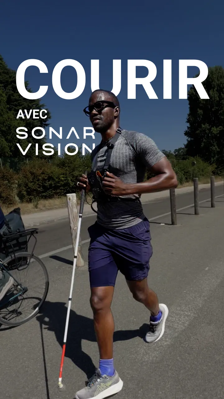
In this article, I explain what was required behind the scenes to achieve this result.
Marc-Alioune's experience and the challenge
Marc-Alioune has been running for years. However, he is severely visually impaired and can only perceive high-contrast elements.
"Grass turns yellow faster and faster during summer, and I can no longer tell the difference between the grass and the path."
Marc-Alioune
This route through the Bois de Boulogne is his regular running path, which he already knows very well, but he faces several recurring difficulties:
- Frequently having to switch between the sidewalk and the road
- Tricky curve tracking along winding paths
- Numerous permanent obstacles forcing him to slow down:
- Utility poles
- Metal manhole covers
- Boulders in the middle or along the edge of the path
He faces two major challenges:
- As fatigue sets in, alertness decreases, significantly raising the risk of injury.
- To avoid getting lost, he must memorize his route by heart, leaving him stuck running the exact same path indefinitely.
For all these reasons, he was looking for a solution to elevate his running experience.
RTK for centimeter-level accuracy in the park
If you've heard of SonarVision before, you might know that our high-accuracy localization primarily relies on our Visual Positioning System (VPS). However, this system requires panoramic street imagery from Apple or Google databases and struggles in heavily wooded areas like the Bois de Boulogne.
To solve this, Augustin and I have been working for several months on seamlessly integrating RTK technology into the SonarVision app.
GNSS (Global Navigation Satellite System) RTK (Real-Time Kinematic) is a satellite positioning technique providing centimeter-level positioning accuracy (under 10 cm / 4 inches) outdoors in open areas, using real-time correction data from ground-based reference stations.
Our initial RTK integration was developed nearly two years ago at the request of Francklin Nguyen Van for his RTKanne project (view on GitHub).
Integrating RTK into SonarVision presented several technical challenges. To make it work seamlessly, we had to:
- Connect the receiver via Bluetooth and handle unexpected disconnections gracefully.
- Transmit the RTCM correction stream via Bluetooth, essential for centimeter-level precision.
- Receive NMEA data streams containing real-time position, accuracy, and satellite count.
Today, many users rely on RTK for impressive use cases, from finding their towel on a crowded beach to hiking across the Île de Bréhat.
Recording a track
We recorded Marc-Alioune's route using SonarVision's track recording feature.
Track recording is particularly well-suited for running because it captures the exact path the runner wants to take.
Below is an interactive map showing the subtle differences between the RTK-recorded track and a route generated by our routing engine , which is highly accurate but doesn't perfectly match Marc-Alioune's personal preferences.
While routes can be refined and simplified afterwards on the SonarVision platform (as shown in the next map), starting from an accurate real-world recording without guessing where the user wants to run is a huge advantage.
Waypoints to personalize the route
SonarVision users have always wanted the ability to customize their routes as much as possible. While automated turn-by-turn directions are great for spontaneous trips, they fall short when you want to highlight a landmark, a tricky turn, or a hazard along the way.
Since July 2026, users can add custom waypoints to their routes. Better yet, these waypoints are persistent and reusable across multiple trips!
On the map below, the smoothed and corrected route from our platform is shown in green, along with the waypoints we placed during our run with Marc-Alioune.
You'll notice, for example, near the barrier at the Route de la Grande Cascade, we actually backtracked to place a waypoint at the precise spot!
What about the actual run?
Using an admin tool, we were able to record Marc-Alioune's actual path as he ran (user routes are otherwise never logged).
The recording starts slightly after the beginning, but you can see how effectively Marc-Alioune follows the route thanks to SonarVision's guidance system! Even as one of the app's developers, I was amazed.
He tends to slightly overshoot turns before correcting, but successfully avoids hazards and follows complex curves smoothly.
As a co-creator of SonarVision, reaching this milestone feels surreal. Four years ago, completing a run like this was unthinkable.
Complete pedestrian independence for blind and visually impaired individuals feels more and more within reach.
Follow and support us
For more updates and behind-the-scenes stories, follow our Instagram page!
If you'd like to support our work, check out our pricing page.