Walk to your destination on your own
SonarVision is the first pedestrian GPS accurate enough to allow a blind or visually impaired user to navigate independently.Now available both outdoors and indoors!
SonarVision has been in service since 2022, used over thousands of trips, by users who are mostly blind. Alex, who is blind, brings you along in this video:
As of late 2025, the SonarVision team is able to scan the inside of any building to enable indoor navigation! Arthur gives you a demo:
Unique features
- Keeps you oriented at all times, especially at crosswalks
- Notifies when a crosswalk starts and ends
- Announces streets both navigated and crossed
- Alerts you of pedestrian islands at crosswalks
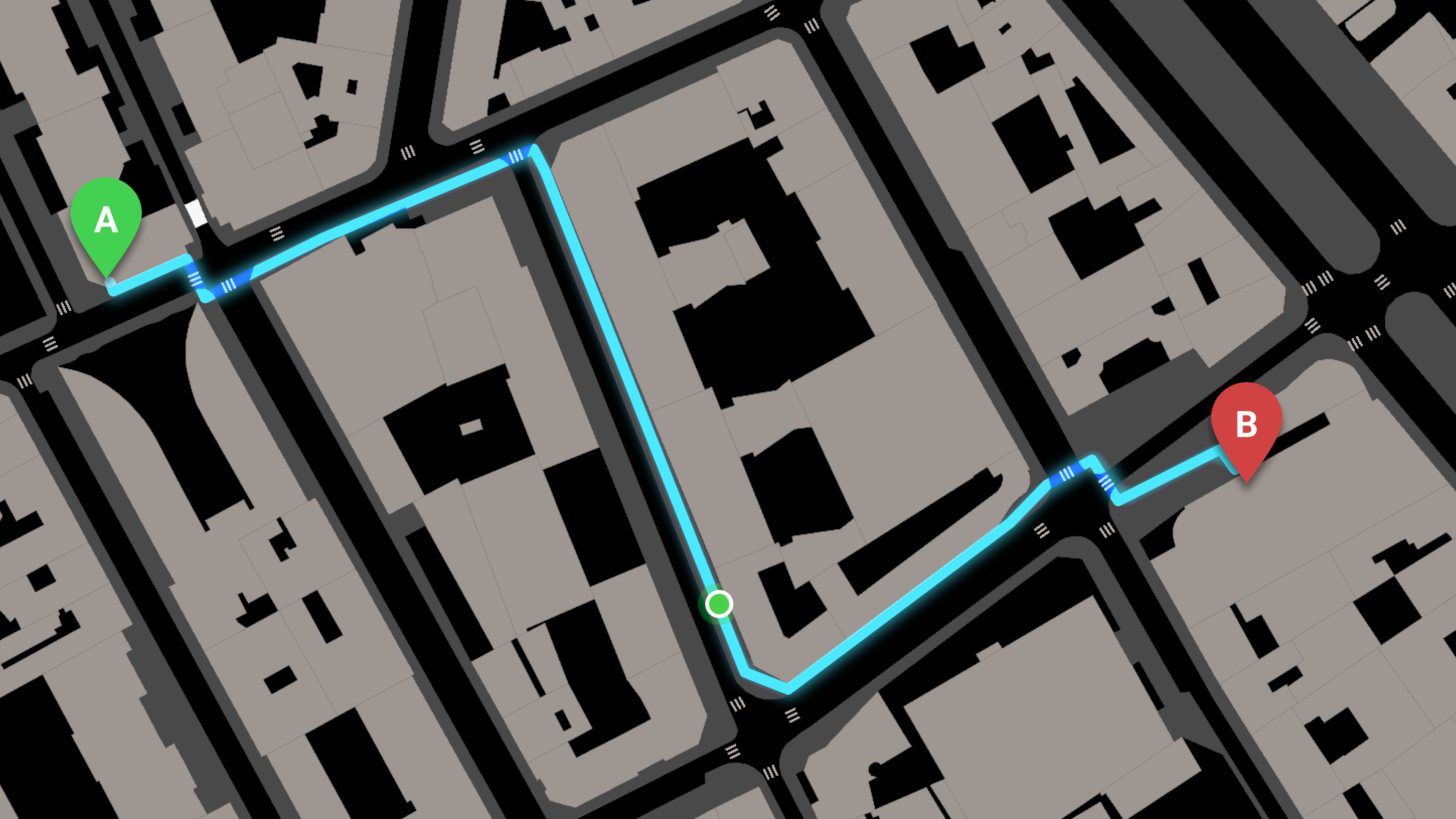
- Guides you to your destination with sub-meter accuracy
Generate trips instantly or customize them manually
The online editing platform allows your loved ones to check, customize, and correct your routes. However, where OpenStreetMap pedestrian mapping is available, you can generate ultra-accurate pedestrian trips in the blink of an eye.
Testimonials
Sébastien
To me, SonarVision is a revolution comparable to the iPhone. Its impact on my autonomy is considerable, although its full potential has yet to be tapped.
Guy
SonarVision has revolutionized my navigation by providing precise guidance, allowing me to avoid environmental hazards. It is essential for my safety and peace of mind, especially when crossing streets. I never leave home without it!
20 times more accurate than a standard GPS
SonarVision uses VPS technology, which stands for Visual Positioning System. It compares images captured by your smartphone with panoramic imagery from Apple Maps and Google Maps, allowing the app to locate you to within 1 meter.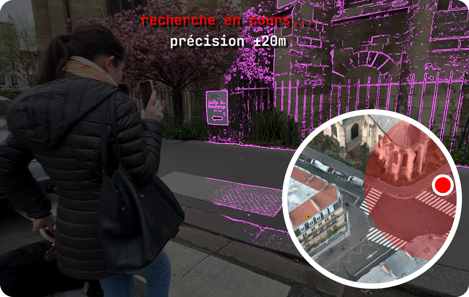 Scan the environment with your smartphone.
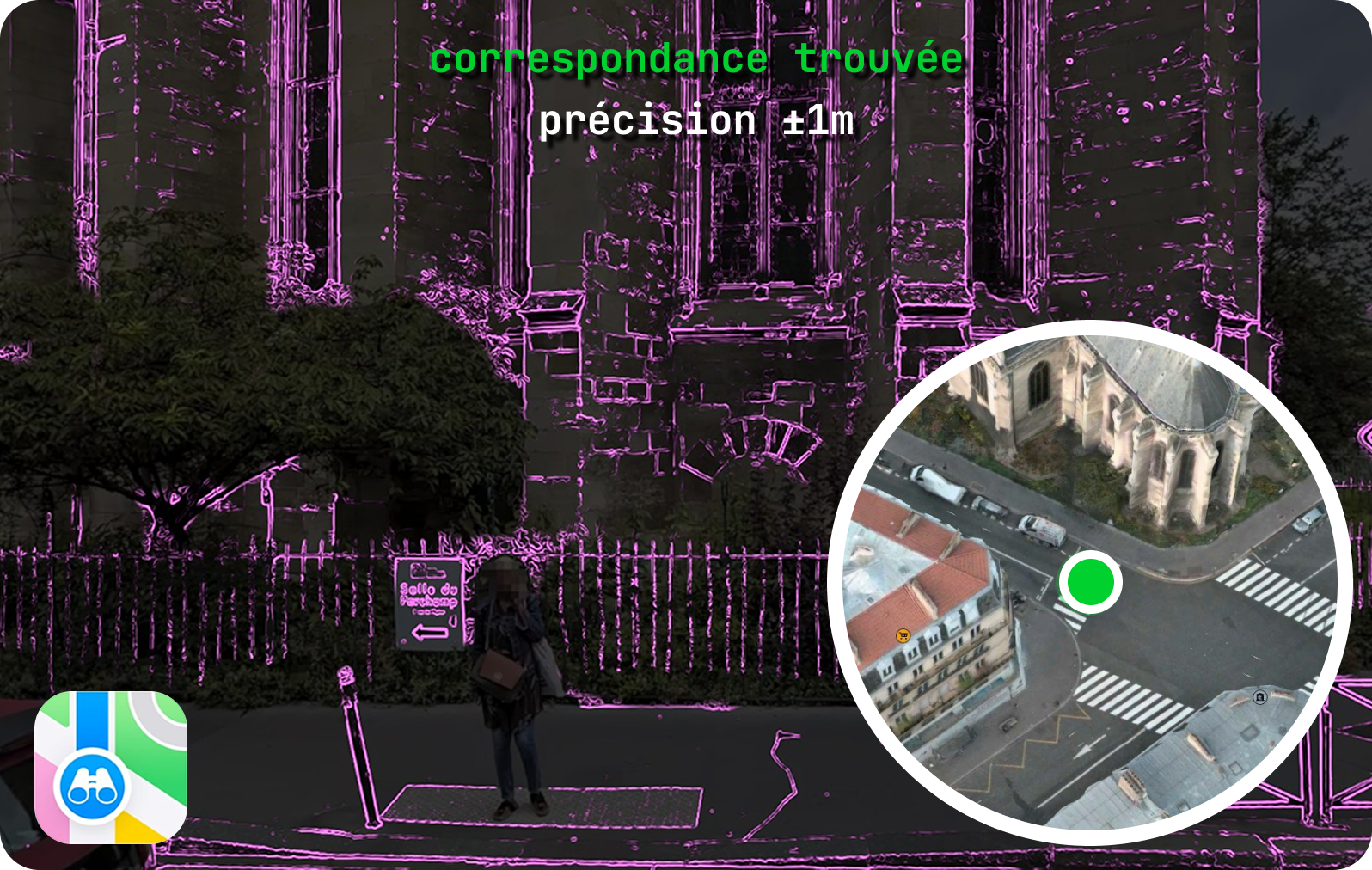 Your position is determined within one meter.
Pricing
SonarVision’s essential features are now completely free for everyone.
- Automatic trips in appropriately mapped areas on OpenStreetMap
- Create and edit private trips with our online editing platform
- Use public trips provided by SonarVision
- Accurately record trips using GPS tracks
Support us
Personal Subscription
Consider subscribing in order to support us as we keep improving SonarVision. You will unlock special perks!15 €per month
Our accessories
Navigation pouch by Feeldom
Order a navigation pouch developed with our partner Feeldom. It is perfect for holding your phone while you use SonarVision.85€including 5€ for shipping
- Deliveries anywhere in France
- Wear the pouch around your neck in order to keep your iPhone aligned with your walking direction.
- Your iPhone is hidden inside the pouch but can see in front of you thanks to a sleek cutout.
- Deliveries anywhere in France
Our paid services
Expert Guidance
In-depth training followed by support from an expert180 €the first month
then 60€ per month for our support service, cancel anytime- A training session tailored to your needs
- Our team of experts helps you plan your routes and build confidence using SonarVision.
Expert Guidance Bundle
Get expert guidance and mapping at a discounted rate.520 €the first month
then 60€ per month for our support service, cancel anytime- A training session tailored to your needs
- Our team of experts helps you plan your routes and build confidence using SonarVision.
- Pedestrian mapping of a 0.50 square kilometer area in OpenStreetMap, enabling the use of automatic trips.
SonarVision Premium
Expert assistance for an entire year.1600 €per year
Employer reimbursement possible- A training session tailored to your needs
- Our team of experts helps you plan your routes and build confidence using SonarVision.
- Pedestrian mapping of a 0.75 square kilometer area in OpenStreetMap, enabling the use of automatic trips.
- Discounted accessory prices.
Mapping service
An expert maps your neighbourhood allowing you to use automatic trips!480 €for 0.50 square kilometers
- Pedestrian mapping of a 0.50 square kilometer area in OpenStreetMap, enabling the use of automatic trips.
Organizations
Our team of experts at your service.Quotebased on your needs
- Provide automatic trips in the area of your choice
- Public trips
- Deploy indoor navigation
- Support and training for your visually impaired employees
- Bulk orders for accessories